FireSat Launch: Early Wildfire Detection System Unveiled
Juliet Rothenberg still vividly recalls the tense moments of evacuating her neighborhood during a California wildfire four years ago. "We were glued to satellite images, constantly checking if the fire had crossed the road," she explains. "If it had, our entire community would have been in jeopardy." Thankfully, the fire didn't cross, but during the evacuation, Juliet found herself waiting hours for updates because, at the time, more detailed data simply wasn’t available.
Wildfires have become a more frequent threat worldwide, with devastating fires reported from Australia to the Amazon and across the United States. The satellite imagery available during Juliet’s evacuation was low-resolution, updated only every 12 hours, and incapable of spotting small fires. "We were left in the dark about our neighborhood's safety," she recalls. "The Bay Area was engulfed in red smoke, but the information we had was no better than what the authorities had."
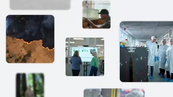
Already aware of the need for better detection, Juliet, who serves as the Product Director of Climate AI efforts at Google Research, has been involved with FireSat. This groundbreaking satellite project is designed to detect and track wildfires at an early stage. This week, FireSat launched its first satellite, marking a significant milestone. Once the full constellation is operational, it will be able to detect a fire as small as 5x5 meters — roughly the size of a classroom — within just 20 minutes, revolutionizing wildfire management.
Finding Fires Earlier and More Accurately
Google Research and satellite manufacturer Muon Space are key partners in the Earth Fire Alliance, the nonprofit behind FireSat. The funding for the first satellite in the constellation was partly provided by Google.org’s AI Collaboratives: Wildfires initiative, which aims to harness AI to mitigate the impact of wildfires. Google.org contributed $13 million to kickstart the FireSat project.
With funding from Google.org and the Moore Foundation, the FireSat project gained the momentum it needed. Chris Van Arsdale, a co-founder working on climate and energy at Google, was driven by the urgency of the situation. "We knew we had to address CO2 emissions from wildfires," he says. Juliet points out the vicious cycle: warmer, drier climates lead to more frequent wildfires, which release more CO2, exacerbating climate change. Better wildfire management not only helps in reducing emissions but also protects lives and communities.
FireSat builds on previous efforts that started in 2020, including the use of AI and satellite imagery to map wildfire boundaries. This information is made available through Google Search and Maps, helping users understand the scope and location of fires in their area, and providing safety alerts to nearby communities.
Despite advancements in AI-based detection, the team recognized the limitations of current satellite imagery. "Existing satellites take images about every five minutes, but they're too coarse to be truly effective," Chris notes. "You'd be lucky to see anything smaller than a few acres, especially in remote mountainous areas where fires often start from lightning strikes and where aerial surveillance might not be consistent."
The team explored various detection methods, including high-altitude drones, but ultimately chose satellites due to their decreasing cost and collaboration with Muon Space, a company specializing in satellite design and operation.
Building (and Testing) a New AI Model
FireSat uses AI to quickly compare current images with historical data, taking into account factors like local infrastructure and weather to identify fires. "Distinguishing actual fires from environmental noise was challenging," Chris admits. "We needed to find the right threshold to differentiate a real fire from sensor issues or misaligned pixels." This required extensive testing and refinement, including a unique experiment where a team member lit a barbecue and firepit in his backyard, allowing the team to test the sensors from a plane overhead. "The sensors picked it up," says Erica Brand, one of the project managers for FireSat.
Readying for Launch — and the Future
Just before the interviews, the first FireSat satellite arrived at the SpaceX launch site. Yesterday, the Google Research team watched as the rocket carrying the satellite soared into the sky. "Since launch dates can shift, we decided to drive rather than fly," Erica says with a laugh. "We called it the 'minivan caravan plan.'" While excited about the launch, the team is even more eager to see how FireSat will help firefighters and emergency responders react more swiftly and effectively.
Beyond immediate response, FireSat will contribute to the broader understanding of wildfires. The data collected will help build a global historical record of fire spread, aiding scientists in modeling and understanding wildfire behavior. "FireSat isn't just about emergency response," Juliet emphasizes. "It's also a powerful tool for reducing greenhouse gas emissions, beautifully addressing both the symptoms and causes of climate change."
Related article
 "Dot AI Companion App Announces Closure, Discontinues Personalized Service"
Dot, an AI companion application designed to function as a personal friend and confidant, will cease operations, according to a Friday announcement from its developers. New Computer, the startup behind Dot, stated on its website that the service will
Anthropic Resolves Legal Case Over AI-Generated Book Piracy
Anthropic has reached a resolution in a significant copyright dispute with US authors, agreeing to a proposed class action settlement that avoids a potentially costly trial. The agreement, filed in court documents this Tuesday, stems from allegations
Figma Releases AI-Powered App Builder Tool to All Users
Figma Make, the innovative prompt-to-app development platform unveiled earlier this year, has officially exited beta and rolled out to all users. This groundbreaking tool joins the ranks of AI-powered coding assistants like Google's Gemini Code Assis
Comments (53)
0/200
"Dot AI Companion App Announces Closure, Discontinues Personalized Service"
Dot, an AI companion application designed to function as a personal friend and confidant, will cease operations, according to a Friday announcement from its developers. New Computer, the startup behind Dot, stated on its website that the service will
Anthropic Resolves Legal Case Over AI-Generated Book Piracy
Anthropic has reached a resolution in a significant copyright dispute with US authors, agreeing to a proposed class action settlement that avoids a potentially costly trial. The agreement, filed in court documents this Tuesday, stems from allegations
Figma Releases AI-Powered App Builder Tool to All Users
Figma Make, the innovative prompt-to-app development platform unveiled earlier this year, has officially exited beta and rolled out to all users. This groundbreaking tool joins the ranks of AI-powered coding assistants like Google's Gemini Code Assis
Comments (53)
0/200
![CarlPerez]() CarlPerez
CarlPerez
 August 25, 2025 at 5:01:22 PM EDT
Wow, FireSat sounds like a game-changer! Early wildfire detection could save so many communities. Hope it’s as reliable as they claim! 🔥


 0
0
![JerryGonzalez]() JerryGonzalez
August 6, 2025 at 7:01:00 PM EDT
JerryGonzalez
August 6, 2025 at 7:01:00 PM EDT
Wow, FireSat sounds like a game-changer for wildfire detection! I love how it uses satellite tech to spot fires early. Could this finally give communities like Juliet’s some peace of mind? 🛰️
0
![PaulTaylor]() PaulTaylor
July 30, 2025 at 9:41:19 PM EDT
PaulTaylor
July 30, 2025 at 9:41:19 PM EDT
The FireSat system sounds like a game-changer for wildfire detection! Juliet's story really hits home—imagine the relief of getting real-time updates instead of panicking over satellite images. Can't wait to see how this tech saves communities! 🔥
0
![GeorgeTaylor]() GeorgeTaylor
April 21, 2025 at 10:19:39 AM EDT
GeorgeTaylor
April 21, 2025 at 10:19:39 AM EDT
FireSat é um salva-vidas! Depois dos incêndios na Califórnia, essa ferramenta me dá tranquilidade. É incrível como pode detectar incêndios cedo. Só gostaria que os alertas fossem mais rápidos. Ainda assim, é essencial para quem vive em áreas propensas a incêndios! 🌲🔥
0
![WalterNelson]() WalterNelson
April 19, 2025 at 6:53:46 PM EDT
WalterNelson
April 19, 2025 at 6:53:46 PM EDT
FireSat is a lifesaver! After the California wildfires, this tool gives me peace of mind. It's amazing how it can spot fires early. Only wish it could send alerts faster. Still, it's a must-have for anyone living in fire-prone areas! 🌲🔥
0
![FredScott]() FredScott
April 18, 2025 at 12:13:09 PM EDT
FredScott
April 18, 2025 at 12:13:09 PM EDT
FireSat is a lifesaver! Knowing that wildfires can be detected early is such a relief. I can sleep better at night knowing my community is safer. The only downside is the cost, but if it keeps us safe, it's worth it. Keep up the good work! 🔥
0
Juliet Rothenberg still vividly recalls the tense moments of evacuating her neighborhood during a California wildfire four years ago. "We were glued to satellite images, constantly checking if the fire had crossed the road," she explains. "If it had, our entire community would have been in jeopardy." Thankfully, the fire didn't cross, but during the evacuation, Juliet found herself waiting hours for updates because, at the time, more detailed data simply wasn’t available.
Wildfires have become a more frequent threat worldwide, with devastating fires reported from Australia to the Amazon and across the United States. The satellite imagery available during Juliet’s evacuation was low-resolution, updated only every 12 hours, and incapable of spotting small fires. "We were left in the dark about our neighborhood's safety," she recalls. "The Bay Area was engulfed in red smoke, but the information we had was no better than what the authorities had."
Already aware of the need for better detection, Juliet, who serves as the Product Director of Climate AI efforts at Google Research, has been involved with FireSat. This groundbreaking satellite project is designed to detect and track wildfires at an early stage. This week, FireSat launched its first satellite, marking a significant milestone. Once the full constellation is operational, it will be able to detect a fire as small as 5x5 meters — roughly the size of a classroom — within just 20 minutes, revolutionizing wildfire management.
Finding Fires Earlier and More Accurately
Google Research and satellite manufacturer Muon Space are key partners in the Earth Fire Alliance, the nonprofit behind FireSat. The funding for the first satellite in the constellation was partly provided by Google.org’s AI Collaboratives: Wildfires initiative, which aims to harness AI to mitigate the impact of wildfires. Google.org contributed $13 million to kickstart the FireSat project.
With funding from Google.org and the Moore Foundation, the FireSat project gained the momentum it needed. Chris Van Arsdale, a co-founder working on climate and energy at Google, was driven by the urgency of the situation. "We knew we had to address CO2 emissions from wildfires," he says. Juliet points out the vicious cycle: warmer, drier climates lead to more frequent wildfires, which release more CO2, exacerbating climate change. Better wildfire management not only helps in reducing emissions but also protects lives and communities.
FireSat builds on previous efforts that started in 2020, including the use of AI and satellite imagery to map wildfire boundaries. This information is made available through Google Search and Maps, helping users understand the scope and location of fires in their area, and providing safety alerts to nearby communities.
Despite advancements in AI-based detection, the team recognized the limitations of current satellite imagery. "Existing satellites take images about every five minutes, but they're too coarse to be truly effective," Chris notes. "You'd be lucky to see anything smaller than a few acres, especially in remote mountainous areas where fires often start from lightning strikes and where aerial surveillance might not be consistent."
The team explored various detection methods, including high-altitude drones, but ultimately chose satellites due to their decreasing cost and collaboration with Muon Space, a company specializing in satellite design and operation.
Building (and Testing) a New AI Model
FireSat uses AI to quickly compare current images with historical data, taking into account factors like local infrastructure and weather to identify fires. "Distinguishing actual fires from environmental noise was challenging," Chris admits. "We needed to find the right threshold to differentiate a real fire from sensor issues or misaligned pixels." This required extensive testing and refinement, including a unique experiment where a team member lit a barbecue and firepit in his backyard, allowing the team to test the sensors from a plane overhead. "The sensors picked it up," says Erica Brand, one of the project managers for FireSat.
Readying for Launch — and the Future
Just before the interviews, the first FireSat satellite arrived at the SpaceX launch site. Yesterday, the Google Research team watched as the rocket carrying the satellite soared into the sky. "Since launch dates can shift, we decided to drive rather than fly," Erica says with a laugh. "We called it the 'minivan caravan plan.'" While excited about the launch, the team is even more eager to see how FireSat will help firefighters and emergency responders react more swiftly and effectively.
Beyond immediate response, FireSat will contribute to the broader understanding of wildfires. The data collected will help build a global historical record of fire spread, aiding scientists in modeling and understanding wildfire behavior. "FireSat isn't just about emergency response," Juliet emphasizes. "It's also a powerful tool for reducing greenhouse gas emissions, beautifully addressing both the symptoms and causes of climate change."


 "Dot AI Companion App Announces Closure, Discontinues Personalized Service"
Dot, an AI companion application designed to function as a personal friend and confidant, will cease operations, according to a Friday announcement from its developers. New Computer, the startup behind Dot, stated on its website that the service will
"Dot AI Companion App Announces Closure, Discontinues Personalized Service"
Dot, an AI companion application designed to function as a personal friend and confidant, will cease operations, according to a Friday announcement from its developers. New Computer, the startup behind Dot, stated on its website that the service will
 Anthropic Resolves Legal Case Over AI-Generated Book Piracy
Anthropic has reached a resolution in a significant copyright dispute with US authors, agreeing to a proposed class action settlement that avoids a potentially costly trial. The agreement, filed in court documents this Tuesday, stems from allegations
Anthropic Resolves Legal Case Over AI-Generated Book Piracy
Anthropic has reached a resolution in a significant copyright dispute with US authors, agreeing to a proposed class action settlement that avoids a potentially costly trial. The agreement, filed in court documents this Tuesday, stems from allegations
 Figma Releases AI-Powered App Builder Tool to All Users
Figma Make, the innovative prompt-to-app development platform unveiled earlier this year, has officially exited beta and rolled out to all users. This groundbreaking tool joins the ranks of AI-powered coding assistants like Google's Gemini Code Assis
August 25, 2025 at 5:01:22 PM EDT
Figma Releases AI-Powered App Builder Tool to All Users
Figma Make, the innovative prompt-to-app development platform unveiled earlier this year, has officially exited beta and rolled out to all users. This groundbreaking tool joins the ranks of AI-powered coding assistants like Google's Gemini Code Assis
August 25, 2025 at 5:01:22 PM EDT
Wow, FireSat sounds like a game-changer! Early wildfire detection could save so many communities. Hope it’s as reliable as they claim! 🔥
0
August 6, 2025 at 7:01:00 PM EDT
Wow, FireSat sounds like a game-changer for wildfire detection! I love how it uses satellite tech to spot fires early. Could this finally give communities like Juliet’s some peace of mind? 🛰️
0
July 30, 2025 at 9:41:19 PM EDT
The FireSat system sounds like a game-changer for wildfire detection! Juliet's story really hits home—imagine the relief of getting real-time updates instead of panicking over satellite images. Can't wait to see how this tech saves communities! 🔥
0
April 21, 2025 at 10:19:39 AM EDT
FireSat é um salva-vidas! Depois dos incêndios na Califórnia, essa ferramenta me dá tranquilidade. É incrível como pode detectar incêndios cedo. Só gostaria que os alertas fossem mais rápidos. Ainda assim, é essencial para quem vive em áreas propensas a incêndios! 🌲🔥
0
April 19, 2025 at 6:53:46 PM EDT
FireSat is a lifesaver! After the California wildfires, this tool gives me peace of mind. It's amazing how it can spot fires early. Only wish it could send alerts faster. Still, it's a must-have for anyone living in fire-prone areas! 🌲🔥
0
April 18, 2025 at 12:13:09 PM EDT
FireSat is a lifesaver! Knowing that wildfires can be detected early is such a relief. I can sleep better at night knowing my community is safer. The only downside is the cost, but if it keeps us safe, it's worth it. Keep up the good work! 🔥
0