

 Home
HomeWhat is GeoDict for material analysis in 2025? Advanced image segmentation guide.
GeoDict is transforming materials science with its advanced tools for image processing and analysis, which are vital for producing high-fidelity simulation outcomes. This article explores the sophisticated and AI-driven image segmentation techniques in GeoDict, showcasing its robust image processing and analysis features, particularly the enhancements introduced in GeoDict 2021. Proper image processing is a cornerstone for achieving reliable simulation data.
Key Points
GeoDict includes a specialized module dedicated to image processing and analysis.
Accurate image processing is fundamental for valid simulation results.
AI-powered segmentation provides deeper insights into material microstructures.
The software offers a full suite for importing, filtering, segmenting, and analyzing images.
GeoDict 2021 introduces significant upgrades to its image processing functionality.
Understanding Image Processing and Analysis in GeoDict
The Importance of Image Processing
Effective image processing is not optional—it is critical for obtaining meaningful simulation data. Inaccurate segmentation of a sample can lead to unreliable simulation outcomes, making precision essential. The quality of segmentation directly influences the validity of simulation results. GeoDict has integrated powerful image processing and analysis tools for many years.
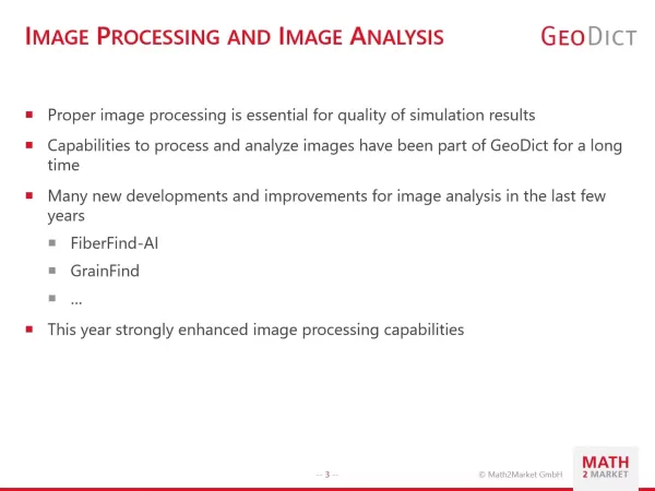
Recent years have seen numerous innovations and improvements in image analysis. We have significantly expanded the platform's image processing capabilities.
While image processing and analysis have long been part of GeoDict, we are now placing even greater emphasis on these areas. Tools like FiberFind-AI and GrainFind exemplify this commitment.
GeoDict: A Comprehensive Toolkit for Image Analysis
GeoDict delivers an integrated workflow for image processing and analysis.
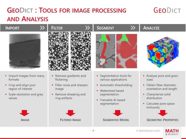
This encompasses essential stages: importing images, applying filters to minimize noise, segmenting images, and conducting detailed analysis. GeoDict supports numerous image formats. If a specific format is not currently supported, users can request its implementation, reflecting GeoDict's dedication to user-driven development and broad application compatibility.
Since proper image processing directly affects simulation quality, it is important to manage each step carefully. This workflow enables users to efficiently prepare images for analysis, leading to more precise and actionable results. The central message is clear: GeoDict serves as your all-in-one image processing solution. The workflow includes these steps:
- Import: Supports a wide range of image formats, with options to crop and align regions of interest, and adjust resolution and grayscale values.
- Filter: Eliminate gradients and flickering, reduce image noise, and sharpen images by removing artifacts like streaks and rings.
- Segment: Access a variety of segmentation methods, including automatic thresholding, watershed algorithms, and trainable AI-based segmentation.
- Analyze: Evaluate pore and grain sizes, determine pore space tortuosity, and measure fiber diameter, orientation, and length.
Enhanced Image Processing Features in GeoDict 2021
What’s New in Image Processing?
GeoDict 2021 offers more sophisticated capabilities. The SuperVoxel Image Filter reduces grayscale value variations, employing techniques like the gradient image and H-Minima transform to maintain topological integrity. This filter acts as a preprocessing step before segmentation.
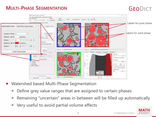
Multi-Phase Segmentation: The watershed algorithm now supports multi-phase segmentation. Users can define grayscale value ranges for specific phases, and the system automatically resolves ambiguous regions, effectively mitigating volume artifacts. This process allows for the creation of more refined and detailed segmented images.
Benefits and Drawbacks of GeoDict
Pros
An extensive suite of image processing and analysis tools.
AI-based segmentation for in-depth material characterization.
Capability to generate statistical digital twins.
GPU-accelerated image filters for superior performance.
A self-contained image processing toolkit, eliminating the need for supplementary software.
Cons
UNet 2D and 3D functionalities can be resource-intensive.
Manual annotation may demand time and specialized expertise.
Boosted Tree models face limitations at larger scales.
The software's complexity may involve a learning period.
GeoDict for Image Processing: Feature Overview
Key Capabilities in Image Processing
GeoDict's image processing features include importing 2D and 3D images in various standard formats, selecting regions of interest (ROI), and performing rescaling and rotation. Users can modify grayscale values to eliminate flickering and gradients, leverage GPU-accelerated 3D image filters, and apply task-specific image filters.
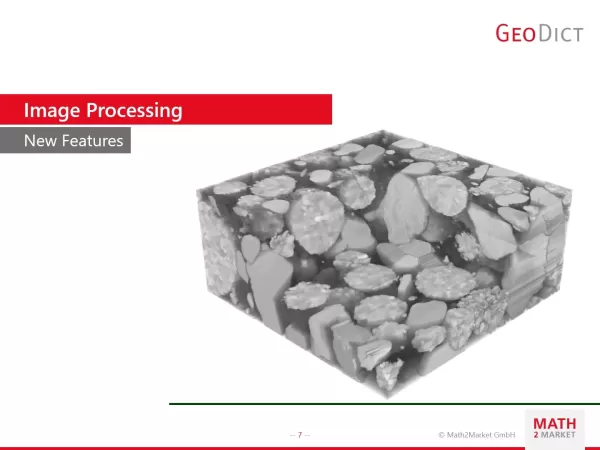
This comprehensive toolkit ensures users have all the resources needed to prepare images for analysis and simulation. GeoDict has significantly reinforced its image processing infrastructure.
Key aspects of image processing:
- Import 2D and 3D images in multiple standard formats
- Region of Interest (ROI) selection, rescaling, and rotation
- Grayscale value adjustments to remove flickering and gradients
- GPU-accelerated 3D image filters
- Specialized image filters
High Impact Use Cases in GeoDict
Real-world Applications of GeoDict
GeoDict delivers tangible results in practical scenarios. Here are some notable achievements in image processing and analysis using GeoDict:
- Complex Fiber Labeling: Accurately labels individual fibers within large CT scans, facilitating detailed fiber analysis and characterization.
- Pore Analysis: Identifies and analyzes millions of pores in CT scans of highly porous materials, offering valuable insights into material structure and performance.
- Binder Identification: Uses AI to detect binders in CT scans without contrast agents, aiding in component analysis and tracking.
- Object Tracking: Tracks moving objects across time-series CT scans, providing dynamic perspectives on material behavior.
Frequently Asked Questions About GeoDict
What image file formats does GeoDict support?
GeoDict supports an extensive array of image file formats. Please inquire if your specific format is not listed.
Does GeoDict require additional software for image processing?
No, GeoDict is a standalone image processing environment, requiring no other software.
Can GeoDict be used for AI-based image segmentation?
Yes, GeoDict incorporates an AI training module for bespoke image segmentation projects.
Digging Deeper: Understanding Advanced Material Analysis
Why is advanced image segmentation important for material analysis?
Advanced image segmentation is indispensable for precise material analysis, as it allows researchers and engineers to differentiate between distinct phases and components within a material sample. This precise identification is vital for several reasons: Accurate Material Characterization: By correctly segmenting phases like pores, grains, or fibers, researchers can obtain exact measurements of their dimensions, morphology, distribution, and alignment. These characteristics are key to understanding the microstructure and its effect on bulk properties. Improved Simulation Inputs: High-quality segmentation provides more accurate inputs for simulations. Predictive models depend on precise material data to forecast behavior under conditions such as mechanical stress, fluid flow, or heat transfer. Inadequate segmentation compromises simulation accuracy and reliability. Enhanced Model Fidelity: Precise segmentation enables the construction of highly detailed, realistic models of a material's internal structure. This is essential for simulating complex physical processes influenced by microstructure. Better Property Prediction: The reliability of predicted material properties, whether mechanical strength, permeability, or thermal conductivity, is closely tied to segmentation quality. Efficient Material Design: Advanced segmentation methods streamline material design. By accurately profiling existing materials, researchers can pinpoint structural attributes that yield desirable properties and optimize these in new designs, speeding up innovation and reducing experimental iterations. Since image analysis and processing are fundamental to segmentation, tools like FiberFind AI and GrainFind represent significant advancements.
Related article
 DeepMind CEO Hassabis: I sleep six hours a day, usually feel energetic around 1 a.m.
Fortune recently featured an interview with Demis Hassabis, CEO of Google DeepMind, revealing his unconventional approach to rest and productivity. Hassabis disclosed that he sleeps very little, structuring his waking hours into two distinct work blo
OpenAI, Anthropic Vie for Market Share Despite Revenue Shortfalls
Despite recent reports suggesting OpenAI missed revenue targets, creating pressure on tech stocks this Tuesday, private AI lab investors remain resilient. Seasoned backers have confirmed they will not reduce investment despite negative media coverage
California AV Compliance: A New Era of Tickets, Geofences, and 1M Miles
Guident operates an AuveTech shuttle in South Florida, managing a four-mile route in West Palm Beach and a one-mile route in Boca Raton using its remote monitoring technology. | Credit: GuidentCalifornia is redefining the regulatory landscape for dri
Related Special Topic Recommendations
Music composition
DeepMind CEO Hassabis: I sleep six hours a day, usually feel energetic around 1 a.m.
Fortune recently featured an interview with Demis Hassabis, CEO of Google DeepMind, revealing his unconventional approach to rest and productivity. Hassabis disclosed that he sleeps very little, structuring his waking hours into two distinct work blo
OpenAI, Anthropic Vie for Market Share Despite Revenue Shortfalls
Despite recent reports suggesting OpenAI missed revenue targets, creating pressure on tech stocks this Tuesday, private AI lab investors remain resilient. Seasoned backers have confirmed they will not reduce investment despite negative media coverage
California AV Compliance: A New Era of Tickets, Geofences, and 1M Miles
Guident operates an AuveTech shuttle in South Florida, managing a four-mile route in West Palm Beach and a one-mile route in Boca Raton using its remote monitoring technology. | Credit: GuidentCalifornia is redefining the regulatory landscape for dri
Related Special Topic Recommendations
Music composition
 AI Stem Separation Tools for Remix Production, Sampling Prep, and Karaoke Masters
2026 Latest Best Top-rated AI Stem Separation Tools Curated for Remix Production, Sampling Prep, and Karaoke Masters. These powerful game-changing tools offer real-world tests to deliver precise audio isolation, boosting productivity significantly. XIX.AI provides a weekly updated free vs paid comparison guide to help you find the must-try solution that suits your needs. Explore now to unlock your AI edge.
 8 tools
 xix.ai
Data Analysis
AI SQL Copilots for Revenue Dashboards, Funnel Analysis, and Product Metrics
xix.ai
Data Analysis
AI SQL Copilots for Revenue Dashboards, Funnel Analysis, and Product Metrics
2026 Latest Best AI SQL Copilots Ranked Top-Rated! XIX.AI curates a powerful game-changing collection for weekly updated real-world tests. These must-try tools help you generate accurate revenue dashboards, analyze sales funnels, and track product metrics swiftly, boosting productivity massively. Explore now to Discover your perfect tool for data-driven decision making! 238 characters
9 tools
xix.ai
Music composition
Best AI Melody Writing Tools for Song Drafts
2026 Latest Best Top-Rated AI Melody Writing Tools for Song Drafts! XIX.AI has curated a highly powerful game-changing collection that goes through rigorous real-world tests to deliver the best writing experience. You can find detailed free vs paid comparisons, accurate rankings, and must-try options designed to help you create stunning song drafts effortlessly and boost your creative productivity significantly. Explore now to discover your perfect tool!
8 tools
xix.ai
chatbot
Best AI Conversation Trainer Tools for Interview Practice
2026 Latest Best Top-rated AI Conversation Trainer Tools for Interview Practice are here on XIX.AI! This curated collection features powerful, game-changing tools that go through rigorous real-world tests to deliver accurate feedback. You’ll find a free vs paid comparison and detailed rankings to help you choose the must-try option that boosts your confidence and skills. Explore now to Discover your perfect tool for interview success!
12 tools
xix.ai
Design & Art
Best AI Style Transfer Tools for Creative Experiments
2026 Latest Best Top-rated AI Style Transfer Tools for Creative Experiments! XIX.AI has curated a powerful, game-changing collection of must-try tools that deliver exceptional results through real-world tests and rigorous rankings. These top solutions help creatives boost productivity significantly by accelerating content creation and unlocking endless creative possibilities. Explore now to discover your perfect tool and start creating today!
9 tools
xix.ai
Comic Creation
Best AI Dialogue Bubble Tools for Visual Storytelling
2026 Latest Best Top-Rated AI Dialogue Bubble Tools for Visual Storytelling are here on XIX.AI! This curated collection features powerful, game-changing tools that help creators boost productivity and overcome creative bottlenecks. Get a free vs paid comparison, see real-world tests, and check the latest rankings to find the must-try solutions perfect for crafting engaging visual narratives. Explore now to discover your ideal tool!
10 tools
xix.ai

 Comments (1)
0/500
Comments (1)
0/500
![PaulSanchez]()
I've been following GeoDict for a while, but this 2025 update on AI-driven image segmentation really caught my eye. How does it compare to other tools like Dragonfly or Avizo? The promise of high-fidelity simulations sounds amazing, but I wonder about the learning curve for new users. Would love to see a side-by-side benchmark! 🧐
GeoDict is transforming materials science with its advanced tools for image processing and analysis, which are vital for producing high-fidelity simulation outcomes. This article explores the sophisticated and AI-driven image segmentation techniques in GeoDict, showcasing its robust image processing and analysis features, particularly the enhancements introduced in GeoDict 2021. Proper image processing is a cornerstone for achieving reliable simulation data.
Key Points
GeoDict includes a specialized module dedicated to image processing and analysis.
Accurate image processing is fundamental for valid simulation results.
AI-powered segmentation provides deeper insights into material microstructures.
The software offers a full suite for importing, filtering, segmenting, and analyzing images.
GeoDict 2021 introduces significant upgrades to its image processing functionality.
Understanding Image Processing and Analysis in GeoDict
The Importance of Image Processing
Effective image processing is not optional—it is critical for obtaining meaningful simulation data. Inaccurate segmentation of a sample can lead to unreliable simulation outcomes, making precision essential. The quality of segmentation directly influences the validity of simulation results. GeoDict has integrated powerful image processing and analysis tools for many years.
Recent years have seen numerous innovations and improvements in image analysis. We have significantly expanded the platform's image processing capabilities.
While image processing and analysis have long been part of GeoDict, we are now placing even greater emphasis on these areas. Tools like FiberFind-AI and GrainFind exemplify this commitment.
GeoDict: A Comprehensive Toolkit for Image Analysis
GeoDict delivers an integrated workflow for image processing and analysis.
This encompasses essential stages: importing images, applying filters to minimize noise, segmenting images, and conducting detailed analysis. GeoDict supports numerous image formats. If a specific format is not currently supported, users can request its implementation, reflecting GeoDict's dedication to user-driven development and broad application compatibility.
Since proper image processing directly affects simulation quality, it is important to manage each step carefully. This workflow enables users to efficiently prepare images for analysis, leading to more precise and actionable results. The central message is clear: GeoDict serves as your all-in-one image processing solution. The workflow includes these steps:
- Import: Supports a wide range of image formats, with options to crop and align regions of interest, and adjust resolution and grayscale values.
- Filter: Eliminate gradients and flickering, reduce image noise, and sharpen images by removing artifacts like streaks and rings.
- Segment: Access a variety of segmentation methods, including automatic thresholding, watershed algorithms, and trainable AI-based segmentation.
- Analyze: Evaluate pore and grain sizes, determine pore space tortuosity, and measure fiber diameter, orientation, and length.
Enhanced Image Processing Features in GeoDict 2021
What’s New in Image Processing?
GeoDict 2021 offers more sophisticated capabilities. The SuperVoxel Image Filter reduces grayscale value variations, employing techniques like the gradient image and H-Minima transform to maintain topological integrity. This filter acts as a preprocessing step before segmentation.
Multi-Phase Segmentation: The watershed algorithm now supports multi-phase segmentation. Users can define grayscale value ranges for specific phases, and the system automatically resolves ambiguous regions, effectively mitigating volume artifacts. This process allows for the creation of more refined and detailed segmented images.
Benefits and Drawbacks of GeoDict
Pros
An extensive suite of image processing and analysis tools.
AI-based segmentation for in-depth material characterization.
Capability to generate statistical digital twins.
GPU-accelerated image filters for superior performance.
A self-contained image processing toolkit, eliminating the need for supplementary software.
Cons
UNet 2D and 3D functionalities can be resource-intensive.
Manual annotation may demand time and specialized expertise.
Boosted Tree models face limitations at larger scales.
The software's complexity may involve a learning period.
GeoDict for Image Processing: Feature Overview
Key Capabilities in Image Processing
GeoDict's image processing features include importing 2D and 3D images in various standard formats, selecting regions of interest (ROI), and performing rescaling and rotation. Users can modify grayscale values to eliminate flickering and gradients, leverage GPU-accelerated 3D image filters, and apply task-specific image filters.
This comprehensive toolkit ensures users have all the resources needed to prepare images for analysis and simulation. GeoDict has significantly reinforced its image processing infrastructure.
Key aspects of image processing:
- Import 2D and 3D images in multiple standard formats
- Region of Interest (ROI) selection, rescaling, and rotation
- Grayscale value adjustments to remove flickering and gradients
- GPU-accelerated 3D image filters
- Specialized image filters
High Impact Use Cases in GeoDict
Real-world Applications of GeoDict
GeoDict delivers tangible results in practical scenarios. Here are some notable achievements in image processing and analysis using GeoDict:
- Complex Fiber Labeling: Accurately labels individual fibers within large CT scans, facilitating detailed fiber analysis and characterization.
- Pore Analysis: Identifies and analyzes millions of pores in CT scans of highly porous materials, offering valuable insights into material structure and performance.
- Binder Identification: Uses AI to detect binders in CT scans without contrast agents, aiding in component analysis and tracking.
- Object Tracking: Tracks moving objects across time-series CT scans, providing dynamic perspectives on material behavior.
Frequently Asked Questions About GeoDict
What image file formats does GeoDict support?
GeoDict supports an extensive array of image file formats. Please inquire if your specific format is not listed.
Does GeoDict require additional software for image processing?
No, GeoDict is a standalone image processing environment, requiring no other software.
Can GeoDict be used for AI-based image segmentation?
Yes, GeoDict incorporates an AI training module for bespoke image segmentation projects.
Digging Deeper: Understanding Advanced Material Analysis
Why is advanced image segmentation important for material analysis?
Advanced image segmentation is indispensable for precise material analysis, as it allows researchers and engineers to differentiate between distinct phases and components within a material sample. This precise identification is vital for several reasons: Accurate Material Characterization: By correctly segmenting phases like pores, grains, or fibers, researchers can obtain exact measurements of their dimensions, morphology, distribution, and alignment. These characteristics are key to understanding the microstructure and its effect on bulk properties. Improved Simulation Inputs: High-quality segmentation provides more accurate inputs for simulations. Predictive models depend on precise material data to forecast behavior under conditions such as mechanical stress, fluid flow, or heat transfer. Inadequate segmentation compromises simulation accuracy and reliability. Enhanced Model Fidelity: Precise segmentation enables the construction of highly detailed, realistic models of a material's internal structure. This is essential for simulating complex physical processes influenced by microstructure. Better Property Prediction: The reliability of predicted material properties, whether mechanical strength, permeability, or thermal conductivity, is closely tied to segmentation quality. Efficient Material Design: Advanced segmentation methods streamline material design. By accurately profiling existing materials, researchers can pinpoint structural attributes that yield desirable properties and optimize these in new designs, speeding up innovation and reducing experimental iterations. Since image analysis and processing are fundamental to segmentation, tools like FiberFind AI and GrainFind represent significant advancements.








 DeepMind CEO Hassabis: I sleep six hours a day, usually feel energetic around 1 a.m.
Fortune recently featured an interview with Demis Hassabis, CEO of Google DeepMind, revealing his unconventional approach to rest and productivity. Hassabis disclosed that he sleeps very little, structuring his waking hours into two distinct work blo
DeepMind CEO Hassabis: I sleep six hours a day, usually feel energetic around 1 a.m.
Fortune recently featured an interview with Demis Hassabis, CEO of Google DeepMind, revealing his unconventional approach to rest and productivity. Hassabis disclosed that he sleeps very little, structuring his waking hours into two distinct work blo
 OpenAI, Anthropic Vie for Market Share Despite Revenue Shortfalls
Despite recent reports suggesting OpenAI missed revenue targets, creating pressure on tech stocks this Tuesday, private AI lab investors remain resilient. Seasoned backers have confirmed they will not reduce investment despite negative media coverage
California AV Compliance: A New Era of Tickets, Geofences, and 1M Miles
Guident operates an AuveTech shuttle in South Florida, managing a four-mile route in West Palm Beach and a one-mile route in Boca Raton using its remote monitoring technology. | Credit: GuidentCalifornia is redefining the regulatory landscape for dri
OpenAI, Anthropic Vie for Market Share Despite Revenue Shortfalls
Despite recent reports suggesting OpenAI missed revenue targets, creating pressure on tech stocks this Tuesday, private AI lab investors remain resilient. Seasoned backers have confirmed they will not reduce investment despite negative media coverage
California AV Compliance: A New Era of Tickets, Geofences, and 1M Miles
Guident operates an AuveTech shuttle in South Florida, managing a four-mile route in West Palm Beach and a one-mile route in Boca Raton using its remote monitoring technology. | Credit: GuidentCalifornia is redefining the regulatory landscape for dri
2026 Latest Best Top-rated AI Stem Separation Tools Curated for Remix Production, Sampling Prep, and Karaoke Masters. These powerful game-changing tools offer real-world tests to deliver precise audio isolation, boosting productivity significantly. XIX.AI provides a weekly updated free vs paid comparison guide to help you find the must-try solution that suits your needs. Explore now to unlock your AI edge.
8 tools
xix.ai
2026 Latest Best AI SQL Copilots Ranked Top-Rated! XIX.AI curates a powerful game-changing collection for weekly updated real-world tests. These must-try tools help you generate accurate revenue dashboards, analyze sales funnels, and track product metrics swiftly, boosting productivity massively. Explore now to Discover your perfect tool for data-driven decision making! 238 characters
9 tools
xix.ai

2026 Latest Best Top-Rated AI Melody Writing Tools for Song Drafts! XIX.AI has curated a highly powerful game-changing collection that goes through rigorous real-world tests to deliver the best writing experience. You can find detailed free vs paid comparisons, accurate rankings, and must-try options designed to help you create stunning song drafts effortlessly and boost your creative productivity significantly. Explore now to discover your perfect tool!
8 tools
xix.ai

2026 Latest Best Top-rated AI Conversation Trainer Tools for Interview Practice are here on XIX.AI! This curated collection features powerful, game-changing tools that go through rigorous real-world tests to deliver accurate feedback. You’ll find a free vs paid comparison and detailed rankings to help you choose the must-try option that boosts your confidence and skills. Explore now to Discover your perfect tool for interview success!
12 tools
xix.ai

2026 Latest Best Top-rated AI Style Transfer Tools for Creative Experiments! XIX.AI has curated a powerful, game-changing collection of must-try tools that deliver exceptional results through real-world tests and rigorous rankings. These top solutions help creatives boost productivity significantly by accelerating content creation and unlocking endless creative possibilities. Explore now to discover your perfect tool and start creating today!
9 tools
xix.ai

2026 Latest Best Top-Rated AI Dialogue Bubble Tools for Visual Storytelling are here on XIX.AI! This curated collection features powerful, game-changing tools that help creators boost productivity and overcome creative bottlenecks. Get a free vs paid comparison, see real-world tests, and check the latest rankings to find the must-try solutions perfect for crafting engaging visual narratives. Explore now to discover your ideal tool!
10 tools
xix.ai

I've been following GeoDict for a while, but this 2025 update on AI-driven image segmentation really caught my eye. How does it compare to other tools like Dragonfly or Avizo? The promise of high-fidelity simulations sounds amazing, but I wonder about the learning curve for new users. Would love to see a side-by-side benchmark! 🧐