首页
首页AI驱动的新开放建筑数据集的开发已揭晓
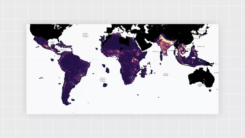
在2021年,Google Research Africa团队启动了Open Buildings,这是一个开源数据集,利用AI和高分辨率卫星图像绘制全球南方的建筑足迹。他们的目标非常直接:填补发展中国家人口和密度数据的巨大空白。现在,第三版数据集已经发布,包含了非洲、南亚和东南亚、拉丁美洲及加勒比地区5800万平方公里内18亿座建筑的多边形。
许多人,包括政府、联合国、研究人员和非营利组织,都在使用Open Buildings来了解人口规模和分布。这帮助他们更好地规划疫苗接种活动和灾难应对。此外,它还通过添加数百万此前未被映射的建筑,增强了Google Maps的功能。
团队总部设在加纳,但成员分布在特拉维夫和苏黎世等地,一直致力于使项目更有用。Google Research项目经理Abdoulaye Diack说:“我们始终处于黑客马拉松模式,尝试新想法并应对挑战。原始数据集无法显示区域随时间的变化——它是静态的。这是我们的合作伙伴非常希望改进的地方。”
商业卫星图像提供商通常关注能带来利润的区域,导致全球约40%的地区,主要是全球南方,缺乏定期高分辨率覆盖。一些偏远地区和非正式定居点完全没有覆盖。同时,欧洲航天局的Sentinel-2卫星提供的开源图像,每五天拍摄一次全球图像,被认为分辨率太低,无法用于建筑检测。
但团队认为这可能不是大问题,于是决定尝试。
首先,他们将Sentinel-2的单帧低分辨率图像输入模型,要求其绘制建筑多边形。Abdoulaye说:“这很困难,但我们看到了潜力。所以我们让模型只提供建筑掩膜——与特定地点关联的二进制像素数据。结果还不错,我们觉得,‘嘿,我们能做到。’”
经过一年的模型调整,他们于上个月推出了Open Buildings 2.5D时序数据集。它覆盖2016年至2023年,提供了全球南方大部分地区的建筑存在和数量的年度快照,以及建筑高度。这显示了城市因发展、灾难和其他因素而发生的变化。用户可以选择一个区域,翻阅年份,观看世界在多彩的形状展示中增长或缩小。
Google Research产品经理Olivia Graham说:“到2050年,约25亿人可能迁往城市,主要是全球南方。这个数据集可能为政府和组织应对这一增长带来巨大改变。如果一个城市在规划医疗、教育等基本服务或建造水电基础设施的位置,这个数据集能显示哪些地区增长很快。”
2018年9月28日,印尼海岸发生7.4级大地震,引发海啸,影响了苏拉威西岛约150万人。该数据集显示了灾后沿海建筑区域的退缩。你可以在我们的交互式Earth Engine应用中查看。
你还可以在Open Buildings 2.5D时序数据集演示中看到埃及新开罗的建设情况。
那么,团队是如何让模型读取Sentinel-2模糊的卫星图像并自信地检测建筑的?他们从提高清晰度开始。
Google Research软件工程师Krishna Sapkota说:“我们使用了一种师生模型设置,既能‘超分辨率’处理低分辨率图像,又能提取建筑足迹。教师模型学会在高分辨率图像中识别建筑,并为学生模型提供标签。学生模型,也就是实际创建数据集的模型,从教师模型的输出中学习。它随后可以处理Sentinel-2的低分辨率图像,并猜测高分辨率版本的样子。”
相关文章
 WordPress.com 现已支持 AI 助手撰写和发布文章,还有更多功能
广受欢迎的网站托管和发布平台 WordPress.com 现已开始引入人工智能助手——这一举措或将重塑网络的呈现方式。该公司于周五宣布,将允许人工智能助手在用户网站上起草、编辑和发布内容,同时还能管理评论、更新和修正元数据,并通过标签和分类对内容进行整理。所有这些操作均通过一个界面进行控制,网站所有者只需使用自然语言命令说明其需求即可。凭借这些新功能,网站几乎可以完全由人工指导的AI代理来创建和运
Kakao Mobility 概述了面向物理人工智能的 L4 级自动驾驶路线图
Kakao Mobility 计划内部自主研发 L4 级自动驾驶技术,作为其物理人工智能战略的一部分。在首尔COEX举行的2026世界IT展上,Kakao Mobility副总裁兼物理AI部门负责人金镇奎(Kim Jin-kyu)介绍了该路线图。他的演讲聚焦于物理AI时代基于出行平台构建的自动驾驶服务。据韩联社报道,这场题为“超越构想,付诸行动:AI驱动现实”的活动汇聚了来自17个国家的460
巴里·迪勒:随着通用人工智能的临近,对萨姆·阿尔特曼的信任已无关紧要
尽管近期有报道暗示相反的情况,但亿万富翁、媒体大亨巴里·迪勒并不认为OpenAI首席执行官山姆·阿尔特曼不可信。本周,迪勒在《华尔街日报》举办的“万物未来”峰会上发表演讲时,为阿尔特曼进行了辩护。此前,阿尔特曼曾遭到一些前同事和董事会成员的指责,称其有时会采取操纵和欺骗手段。作为阿尔特曼的朋友,迪勒是在回答一个关于人们是否应该信任阿尔特曼以确保人工智能造福人类的问题时作出上述表态的。具体而言,提问
相关专题推荐
商业
WordPress.com 现已支持 AI 助手撰写和发布文章,还有更多功能
广受欢迎的网站托管和发布平台 WordPress.com 现已开始引入人工智能助手——这一举措或将重塑网络的呈现方式。该公司于周五宣布,将允许人工智能助手在用户网站上起草、编辑和发布内容,同时还能管理评论、更新和修正元数据,并通过标签和分类对内容进行整理。所有这些操作均通过一个界面进行控制,网站所有者只需使用自然语言命令说明其需求即可。凭借这些新功能,网站几乎可以完全由人工指导的AI代理来创建和运
Kakao Mobility 概述了面向物理人工智能的 L4 级自动驾驶路线图
Kakao Mobility 计划内部自主研发 L4 级自动驾驶技术,作为其物理人工智能战略的一部分。在首尔COEX举行的2026世界IT展上,Kakao Mobility副总裁兼物理AI部门负责人金镇奎(Kim Jin-kyu)介绍了该路线图。他的演讲聚焦于物理AI时代基于出行平台构建的自动驾驶服务。据韩联社报道,这场题为“超越构想,付诸行动:AI驱动现实”的活动汇聚了来自17个国家的460
巴里·迪勒:随着通用人工智能的临近,对萨姆·阿尔特曼的信任已无关紧要
尽管近期有报道暗示相反的情况,但亿万富翁、媒体大亨巴里·迪勒并不认为OpenAI首席执行官山姆·阿尔特曼不可信。本周,迪勒在《华尔街日报》举办的“万物未来”峰会上发表演讲时,为阿尔特曼进行了辩护。此前,阿尔特曼曾遭到一些前同事和董事会成员的指责,称其有时会采取操纵和欺骗手段。作为阿尔特曼的朋友,迪勒是在回答一个关于人们是否应该信任阿尔特曼以确保人工智能造福人类的问题时作出上述表态的。具体而言,提问
相关专题推荐
商业
 最佳 AI 费用追踪工具:扫描收据并自动分类企业开支
2026年最新最佳AI报销管理工具:广受好评的解决方案,可自动扫描收据并分类企业支出。探索这些功能强大、颠覆传统的解决方案,助您轻松管理报销、精准追踪财务并简化合规流程。我们精心整理并每周更新的免费与付费选项对比指南,助您找到最适合的工具。通过XIX.AI的专家精选,释放您的AI优势。
 10 个工具
 xix.ai
商业
最佳人工智能招聘工具:筛选简历并自动安排候选人面试
xix.ai
商业
最佳人工智能招聘工具:筛选简历并自动安排候选人面试
在 XIX.AI 上探索 2026 年最新、评价最高的人工智能招聘工具。我们精心筛选的清单汇集了功能强大、颠覆传统的解决方案,可帮助您筛选简历并自动安排候选人面试。通过实际测试和每周更新的排名,对比免费与付费选项。立即找到最适合您的招聘助手,优化您的招聘流程!
10 个工具
xix.ai
生产率
AI个人健康与专注力教练:缓解倦怠,提升精神能量
立即访问 XIX.AI,探索 2026 年最优秀的 AI 个人健康与专注力教练。我们的精选排行榜汇集了广受好评、具有颠覆性意义的工具,助您缓解倦怠、提升精神能量。通过真实案例分析,对比免费与付费选项。立即开启通往巅峰生产力和身心健康的道路。
10 个工具
xix.ai
聊天机器人
备受好评的AI浪漫聊天机器人:凭借稳定的个性建立长期关系
探索2026年最新、评价最高的人工智能浪漫聊天机器人,助您建立真实而长久的联系。我们的精选清单涵盖了功能强大且性格鲜明的聊天机器人,并提供了免费与付费版本的对比分析以及实际测试结果。在XIX.AI上找到您的完美伴侣,立即开始建立联系吧。
10 个工具
xix.ai
教育与学习
最佳AI数据科学导师:精通SQL、Pandas及机器学习工作流程
探索2026年最优秀的人工智能数据科学导师,帮助他们掌握SQL、Pandas以及机器学习工作流程。在XIX.AI上查看我们精心挑选的顶级导师名单,获得强大而具有变革性的指导。通过对比免费和付费选项,并结合实际应用案例进行了解,今天就开启你的数据科学精通之路吧。
10 个工具
xix.ai
聊天机器人
最佳AI调情与对话训练工具:实时提升社交魅力与自信
在 XIX.AI 上探索 2026 年最优秀的 AI 调情与对话训练工具。我们精心挑选的高评分工具助您实时提升社交魅力与自信。探索这些必试的、颠覆性的工具,查看免费版与付费版的对比,并了解每周更新的排行榜。立即开启您的社交优势。
10 个工具
xix.ai

 评论 (28)
0/500
评论 (28)
0/500
![WillieJohnson]()
This dataset sounds like a game-changer for urban planning! Mapping buildings in the Global South with AI is super cool, but I wonder how accurate it is in super dense areas. 🏙️
![JustinHarris]()
Super cool to see AI mapping buildings in the Global South! 😮 Makes me wonder how this could help urban planning or disaster response.
![KennethJohnson]()
This dataset sounds like a game-changer for urban planning! 😮 I wonder how accurate those AI-mapped footprints are compared to real-world buildings.
![CarlHill]()
新しいオープンビルディングデータセットのAI駆動開発はすごくクール!AIと衛星画像でグローバルサウスの建物のフットプリントをマッピングできるなんて驚きだ。でも、データが少し圧倒的すぎる。とはいえ、人口密度を理解するのに素晴らしいツールだよ!🌍📊
![LarryMartin]()
새로운 오픈 빌딩 데이터셋의 AI 기반 개발은 정말 멋져요! AI와 위성 이미지를 통해 글로벌 사우스의 건물 발자국을 매핑할 수 있다는 게 놀랍네요. 하지만 데이터가 조금 압도적이에요. 그래도 인구 밀도를 이해하는 데 좋은 도구예요! 🌍📊
![StevenGreen]()
El Desarrollo Impulsado por IA del Nuevo Conjunto de Datos de Edificios Abiertos es súper genial. Es increíble cómo la IA y las imágenes satelitales pueden mapear las huellas de los edificios en el Sur Global. Pero, los datos pueden ser un poco abrumadores. Aún así, es una gran herramienta para entender la densidad de población. 🌍📊
在2021年,Google Research Africa团队启动了Open Buildings,这是一个开源数据集,利用AI和高分辨率卫星图像绘制全球南方的建筑足迹。他们的目标非常直接:填补发展中国家人口和密度数据的巨大空白。现在,第三版数据集已经发布,包含了非洲、南亚和东南亚、拉丁美洲及加勒比地区5800万平方公里内18亿座建筑的多边形。
许多人,包括政府、联合国、研究人员和非营利组织,都在使用Open Buildings来了解人口规模和分布。这帮助他们更好地规划疫苗接种活动和灾难应对。此外,它还通过添加数百万此前未被映射的建筑,增强了Google Maps的功能。
商业卫星图像提供商通常关注能带来利润的区域,导致全球约40%的地区,主要是全球南方,缺乏定期高分辨率覆盖。一些偏远地区和非正式定居点完全没有覆盖。同时,欧洲航天局的Sentinel-2卫星提供的开源图像,每五天拍摄一次全球图像,被认为分辨率太低,无法用于建筑检测。
但团队认为这可能不是大问题,于是决定尝试。
首先,他们将Sentinel-2的单帧低分辨率图像输入模型,要求其绘制建筑多边形。Abdoulaye说:“这很困难,但我们看到了潜力。所以我们让模型只提供建筑掩膜——与特定地点关联的二进制像素数据。结果还不错,我们觉得,‘嘿,我们能做到。’”
经过一年的模型调整,他们于上个月推出了Open Buildings 2.5D时序数据集。它覆盖2016年至2023年,提供了全球南方大部分地区的建筑存在和数量的年度快照,以及建筑高度。这显示了城市因发展、灾难和其他因素而发生的变化。用户可以选择一个区域,翻阅年份,观看世界在多彩的形状展示中增长或缩小。
Google Research产品经理Olivia Graham说:“到2050年,约25亿人可能迁往城市,主要是全球南方。这个数据集可能为政府和组织应对这一增长带来巨大改变。如果一个城市在规划医疗、教育等基本服务或建造水电基础设施的位置,这个数据集能显示哪些地区增长很快。”
那么,团队是如何让模型读取Sentinel-2模糊的卫星图像并自信地检测建筑的?他们从提高清晰度开始。
Google Research软件工程师Krishna Sapkota说:“我们使用了一种师生模型设置,既能‘超分辨率’处理低分辨率图像,又能提取建筑足迹。教师模型学会在高分辨率图像中识别建筑,并为学生模型提供标签。学生模型,也就是实际创建数据集的模型,从教师模型的输出中学习。它随后可以处理Sentinel-2的低分辨率图像,并猜测高分辨率版本的样子。”


 WordPress.com 现已支持 AI 助手撰写和发布文章,还有更多功能
广受欢迎的网站托管和发布平台 WordPress.com 现已开始引入人工智能助手——这一举措或将重塑网络的呈现方式。该公司于周五宣布,将允许人工智能助手在用户网站上起草、编辑和发布内容,同时还能管理评论、更新和修正元数据,并通过标签和分类对内容进行整理。所有这些操作均通过一个界面进行控制,网站所有者只需使用自然语言命令说明其需求即可。凭借这些新功能,网站几乎可以完全由人工指导的AI代理来创建和运
Kakao Mobility 概述了面向物理人工智能的 L4 级自动驾驶路线图
Kakao Mobility 计划内部自主研发 L4 级自动驾驶技术,作为其物理人工智能战略的一部分。在首尔COEX举行的2026世界IT展上,Kakao Mobility副总裁兼物理AI部门负责人金镇奎(Kim Jin-kyu)介绍了该路线图。他的演讲聚焦于物理AI时代基于出行平台构建的自动驾驶服务。据韩联社报道,这场题为“超越构想,付诸行动:AI驱动现实”的活动汇聚了来自17个国家的460
WordPress.com 现已支持 AI 助手撰写和发布文章,还有更多功能
广受欢迎的网站托管和发布平台 WordPress.com 现已开始引入人工智能助手——这一举措或将重塑网络的呈现方式。该公司于周五宣布,将允许人工智能助手在用户网站上起草、编辑和发布内容,同时还能管理评论、更新和修正元数据,并通过标签和分类对内容进行整理。所有这些操作均通过一个界面进行控制,网站所有者只需使用自然语言命令说明其需求即可。凭借这些新功能,网站几乎可以完全由人工指导的AI代理来创建和运
Kakao Mobility 概述了面向物理人工智能的 L4 级自动驾驶路线图
Kakao Mobility 计划内部自主研发 L4 级自动驾驶技术,作为其物理人工智能战略的一部分。在首尔COEX举行的2026世界IT展上,Kakao Mobility副总裁兼物理AI部门负责人金镇奎(Kim Jin-kyu)介绍了该路线图。他的演讲聚焦于物理AI时代基于出行平台构建的自动驾驶服务。据韩联社报道,这场题为“超越构想,付诸行动:AI驱动现实”的活动汇聚了来自17个国家的460
 巴里·迪勒:随着通用人工智能的临近,对萨姆·阿尔特曼的信任已无关紧要
尽管近期有报道暗示相反的情况,但亿万富翁、媒体大亨巴里·迪勒并不认为OpenAI首席执行官山姆·阿尔特曼不可信。本周,迪勒在《华尔街日报》举办的“万物未来”峰会上发表演讲时,为阿尔特曼进行了辩护。此前,阿尔特曼曾遭到一些前同事和董事会成员的指责,称其有时会采取操纵和欺骗手段。作为阿尔特曼的朋友,迪勒是在回答一个关于人们是否应该信任阿尔特曼以确保人工智能造福人类的问题时作出上述表态的。具体而言,提问
巴里·迪勒:随着通用人工智能的临近,对萨姆·阿尔特曼的信任已无关紧要
尽管近期有报道暗示相反的情况,但亿万富翁、媒体大亨巴里·迪勒并不认为OpenAI首席执行官山姆·阿尔特曼不可信。本周,迪勒在《华尔街日报》举办的“万物未来”峰会上发表演讲时,为阿尔特曼进行了辩护。此前,阿尔特曼曾遭到一些前同事和董事会成员的指责,称其有时会采取操纵和欺骗手段。作为阿尔特曼的朋友,迪勒是在回答一个关于人们是否应该信任阿尔特曼以确保人工智能造福人类的问题时作出上述表态的。具体而言,提问

2026年最新最佳AI报销管理工具:广受好评的解决方案,可自动扫描收据并分类企业支出。探索这些功能强大、颠覆传统的解决方案,助您轻松管理报销、精准追踪财务并简化合规流程。我们精心整理并每周更新的免费与付费选项对比指南,助您找到最适合的工具。通过XIX.AI的专家精选,释放您的AI优势。
10 个工具
xix.ai

在 XIX.AI 上探索 2026 年最新、评价最高的人工智能招聘工具。我们精心筛选的清单汇集了功能强大、颠覆传统的解决方案,可帮助您筛选简历并自动安排候选人面试。通过实际测试和每周更新的排名,对比免费与付费选项。立即找到最适合您的招聘助手,优化您的招聘流程!
10 个工具
xix.ai

立即访问 XIX.AI,探索 2026 年最优秀的 AI 个人健康与专注力教练。我们的精选排行榜汇集了广受好评、具有颠覆性意义的工具,助您缓解倦怠、提升精神能量。通过真实案例分析,对比免费与付费选项。立即开启通往巅峰生产力和身心健康的道路。
10 个工具
xix.ai

探索2026年最新、评价最高的人工智能浪漫聊天机器人,助您建立真实而长久的联系。我们的精选清单涵盖了功能强大且性格鲜明的聊天机器人,并提供了免费与付费版本的对比分析以及实际测试结果。在XIX.AI上找到您的完美伴侣,立即开始建立联系吧。
10 个工具
xix.ai
探索2026年最优秀的人工智能数据科学导师,帮助他们掌握SQL、Pandas以及机器学习工作流程。在XIX.AI上查看我们精心挑选的顶级导师名单,获得强大而具有变革性的指导。通过对比免费和付费选项,并结合实际应用案例进行了解,今天就开启你的数据科学精通之路吧。
10 个工具
xix.ai

在 XIX.AI 上探索 2026 年最优秀的 AI 调情与对话训练工具。我们精心挑选的高评分工具助您实时提升社交魅力与自信。探索这些必试的、颠覆性的工具,查看免费版与付费版的对比,并了解每周更新的排行榜。立即开启您的社交优势。
10 个工具
xix.ai

This dataset sounds like a game-changer for urban planning! Mapping buildings in the Global South with AI is super cool, but I wonder how accurate it is in super dense areas. 🏙️
Super cool to see AI mapping buildings in the Global South! 😮 Makes me wonder how this could help urban planning or disaster response.
This dataset sounds like a game-changer for urban planning! 😮 I wonder how accurate those AI-mapped footprints are compared to real-world buildings.
新しいオープンビルディングデータセットのAI駆動開発はすごくクール!AIと衛星画像でグローバルサウスの建物のフットプリントをマッピングできるなんて驚きだ。でも、データが少し圧倒的すぎる。とはいえ、人口密度を理解するのに素晴らしいツールだよ!🌍📊
새로운 오픈 빌딩 데이터셋의 AI 기반 개발은 정말 멋져요! AI와 위성 이미지를 통해 글로벌 사우스의 건물 발자국을 매핑할 수 있다는 게 놀랍네요. 하지만 데이터가 조금 압도적이에요. 그래도 인구 밀도를 이해하는 데 좋은 도구예요! 🌍📊
El Desarrollo Impulsado por IA del Nuevo Conjunto de Datos de Edificios Abiertos es súper genial. Es increíble cómo la IA y las imágenes satelitales pueden mapear las huellas de los edificios en el Sur Global. Pero, los datos pueden ser un poco abrumadores. Aún así, es una gran herramienta para entender la densidad de población. 🌍📊