Home
HomeWildfire Maps Now Cover New Regions in Europe and Africa
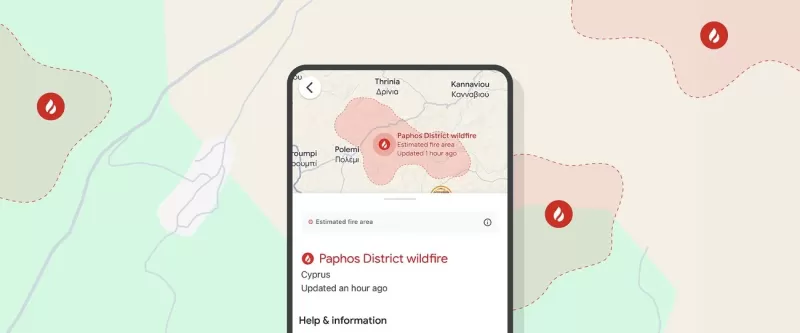
In July, wildfires raged across the Greek islands of Kos, Chios, and Crete, keeping firefighters busy through the night. Meanwhile, in Spain's Extremadura region, authorities mobilized 60 personnel to tackle one of the 18 forest fires threatening the area. Over in Cyprus, a wildfire in the Paphos region was sparked by light refracted through broken glass. Reports suggest that fire-prone areas in Europe have doubled over the past 50 years.
Thanks to AI, we can now track wildfire boundaries in detail on Search and Maps, and send location-based push notifications. This summer, we're rolling out this tool to 15 more countries in Europe and Africa:
- Andorra
- Bosnia & Herzegovina
- Croatia
- Cyprus
- France
- Greece
- Italy
- Kenya
- Monaco
- Montenegro
- Portugal
- Rwanda
- Slovenia
- Spain
- Türkiye
We're making this info available through alerts and features that help folks stay safe near wildfires.
Accurate and Reliable Tracking
Google's AI-powered wildfire tracking model uses a bunch of data sources, including different satellite imagery sets. We check our model against our own fire scar model—shapes we figure out after a fire's been put out—based on past wildfire data. Other AI models help confirm if there's really a fire, which all together gives us more accurate wildfire boundaries than just using satellite images.
Accessible and Useful Information When People Need It
As we rolled out this new feature this summer, we mapped over 40 wildfires in southern Europe, including fires in Spain, Greece, and Cyprus last month, and others from Portugal to Kenya.
We displayed these wildfire boundaries on Search and Maps and sent out notifications to help people stay informed and safe. In the first week of July alone, over 1.4 million people saw our wildfire info after fires broke out across Europe and Africa.
Our wildfire boundary tracking is designed to be helpful for both locals and tourists who might not speak the local language. Notifications are tailored based on user settings and preferred languages, so travelers can get timely, local wildfire updates in their own language during peak tourist season.
We also overlay this info on Google Maps driving directions, so travelers can see if there are wildfires near their planned route.
This is just one way we're using AI to help communities worldwide deal with climate change and its dangers. We've launched this feature in countries hit hard by wildfires in recent summers, based on how well our model works in each place. As we keep improving our models, we hope to bring this to more countries and keep sharing vital info when people need it most.
*Wildfire tracking is already available in the US, Canada, Australia, Brazil, Argentina, Chile, and Mexico.
 Google Photos brings Clueless's iconic closet to life with AI
Google Photos announced a new AI-powered feature on Wednesday that will soon turn photos of your clothes into a digital closet, letting you create fresh outfit combinations and even virtually try them on. The concept clearly draws inspiration from Ch
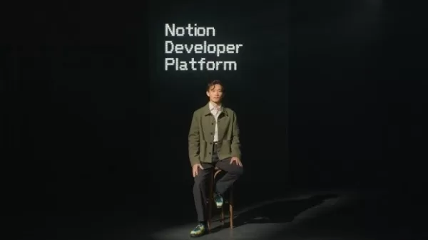
Notion transforms its workspace into a hub for AI agents
Notion, the productivity software company, is entering the agentic era.During a live-streamed product announcement on Wednesday, Notion—best known for its collaborative note-taking app—unveiled a new developer platform that extends the capabilities o
ElevenLabs names BlackRock, Jamie Foxx, Eva Longoria as new investors
ElevenLabs, the voice AI company, has disclosed additional investors in its $500 million Series D round, originally announced in February. These include institutional investors like BlackRock, Wellington, D.E. Shaw, and Schroders; corporations such a
Related Special Topic Recommendations
chatbot
Google Photos brings Clueless's iconic closet to life with AI
Google Photos announced a new AI-powered feature on Wednesday that will soon turn photos of your clothes into a digital closet, letting you create fresh outfit combinations and even virtually try them on. The concept clearly draws inspiration from Ch
Notion transforms its workspace into a hub for AI agents
Notion, the productivity software company, is entering the agentic era.During a live-streamed product announcement on Wednesday, Notion—best known for its collaborative note-taking app—unveiled a new developer platform that extends the capabilities o
ElevenLabs names BlackRock, Jamie Foxx, Eva Longoria as new investors
ElevenLabs, the voice AI company, has disclosed additional investors in its $500 million Series D round, originally announced in February. These include institutional investors like BlackRock, Wellington, D.E. Shaw, and Schroders; corporations such a
Related Special Topic Recommendations
chatbot
 Best Custom AI Girlfriend Generators: Design Unique Personalities, Hobbies, and Backstories
Discover the 2026 best custom AI girlfriend generators on XIX.AI. Explore our top-rated, curated list for designing unique personalities, hobbies, and deep backstories. Compare free vs paid options with real-world insights. Unlock your perfect creative companion today.
 10 tools
 xix.ai
Productivity
AI Architecture Designers: Build Scalable System Architectures Using Natural Language
xix.ai
Productivity
AI Architecture Designers: Build Scalable System Architectures Using Natural Language
Discover the 2026 best AI architecture design tools on XIX.AI. Our curated, top-rated list features powerful, game-changing solutions to build scalable system architectures using natural language. Compare free vs paid options with real-world insights. Unlock your AI edge and streamline development today.
10 tools
xix.ai
Comic Creation
AI Character Profile Creators: Generate Detailed Backstories & Visual Refs for Manga Leads
2026 Latest Best AI Character Profile Creators: Discover top-rated tools to generate detailed backstories and visual references for your manga leads. Our curated, weekly-updated list compares free vs paid options based on real-world tests. Find powerful, game-changing solutions to craft compelling characters and streamline your creative workflow. Explore the rankings on XIX.AI and unlock your perfect storytelling ally today.
10 tools
xix.ai
Health & Wellness
AI Pregnancy Copilots: Generate Safe Trimester-by-Trimester Workout & Nutrition Plans
Discover the 2026 best AI pregnancy copilots for safe, personalized trimester-by-trimester workout and nutrition plans. Get top-rated, curated recommendations with free vs paid comparisons and real-world insights. Unlock your healthiest pregnancy journey with XIX.AI's expert guide. Explore now.
10 tools
xix.ai
writing
Best Free AI Undetectable Writers: Turn Robotic Drafts into Natural, Human-Like Prose
Discover the 2026 best free undetectable AI writers at XIX.AI. Our top-rated, curated list helps you transform robotic drafts into natural, human-like prose. Compare free vs paid options with real-world tests and weekly updated rankings. Unlock your AI writing edge today.
10 tools
xix.ai
Image editing
AI Art Generators for Short-Drama Storyboards: Fantasy & Urban Romance Characters
2026 Latest: Discover the best AI art generators for short-drama storyboards. Our curated list features top-rated tools for creating compelling fantasy and urban romance characters. Compare free vs paid options, see real-world test results, and find your perfect creative partner. Get weekly updated rankings and expert insights from XIX.AI. Start visualizing your story today!
10 tools
xix.ai

 Comments (29)
0/500
Comments (29)
0/500
![RogerGonzalez]()
¡Menuda noticia! 😱 Con los incendios cada vez más frecuentes aquí en España, esto llega en el momento justo. Me pregunto si estas nuevas coberturas cartográficas incluirán también zonas de riesgo en el Mediterráneo, que últimamente parece una yesca. ¡Ojalá sirva para mejorar la prevención! 🔥
![ThomasMiller]()
Les cartes des incendies couvrent maintenant plus de régions, c'est impressionnant ! Mais franchement, ça fait peur de voir autant de feux en Europe et en Afrique. Est-ce que la tech peut vraiment aider à gérer ça ou c'est juste pour faire joli ? 😕
![JonathanLewis]()
Wildfires are getting wilder every year! 😓 This map expansion is cool, but it’s scary how fast these fires spread across Europe and Africa. Hope the tech helps firefighters save more land!
![KeithSmith]()
Wildfire maps expanding to new regions is super cool! It's wild how tech can track blazes in places like Greece and Cyprus now. Hope it helps firefighters save more lives! 🔥
![JustinJackson]()
Os novos mapas de incêndios florestais são um salva-vidas para rastrear incêndios na Europa e na África! São detalhados e atualizados frequentemente, o que é ótimo. Mas a interface poderia ser mais amigável ao usuário. Ainda assim, é essencial para quem está preocupado com incêndios florestais nessas regiões. 🔥🌍
![WillieJackson]()
¡Los nuevos mapas de incendios forestales son un salvavidas para seguir los incendios en Europa y África! Son detallados y se actualizan con frecuencia, lo cual es genial. Pero la interfaz podría ser más amigable para el usuario. Aún así, es imprescindible para cualquiera preocupado por los incendios forestales en estas regiones. 🔥🌍
In July, wildfires raged across the Greek islands of Kos, Chios, and Crete, keeping firefighters busy through the night. Meanwhile, in Spain's Extremadura region, authorities mobilized 60 personnel to tackle one of the 18 forest fires threatening the area. Over in Cyprus, a wildfire in the Paphos region was sparked by light refracted through broken glass. Reports suggest that fire-prone areas in Europe have doubled over the past 50 years.
Thanks to AI, we can now track wildfire boundaries in detail on Search and Maps, and send location-based push notifications. This summer, we're rolling out this tool to 15 more countries in Europe and Africa:
- Andorra
- Bosnia & Herzegovina
- Croatia
- Cyprus
- France
- Greece
- Italy
- Kenya
- Monaco
- Montenegro
- Portugal
- Rwanda
- Slovenia
- Spain
- Türkiye
We're making this info available through alerts and features that help folks stay safe near wildfires.
Accurate and Reliable Tracking
Google's AI-powered wildfire tracking model uses a bunch of data sources, including different satellite imagery sets. We check our model against our own fire scar model—shapes we figure out after a fire's been put out—based on past wildfire data. Other AI models help confirm if there's really a fire, which all together gives us more accurate wildfire boundaries than just using satellite images.
Accessible and Useful Information When People Need It
As we rolled out this new feature this summer, we mapped over 40 wildfires in southern Europe, including fires in Spain, Greece, and Cyprus last month, and others from Portugal to Kenya.
Our wildfire boundary tracking is designed to be helpful for both locals and tourists who might not speak the local language. Notifications are tailored based on user settings and preferred languages, so travelers can get timely, local wildfire updates in their own language during peak tourist season.
We also overlay this info on Google Maps driving directions, so travelers can see if there are wildfires near their planned route.
*Wildfire tracking is already available in the US, Canada, Australia, Brazil, Argentina, Chile, and Mexico.


 Google Photos brings Clueless's iconic closet to life with AI
Google Photos announced a new AI-powered feature on Wednesday that will soon turn photos of your clothes into a digital closet, letting you create fresh outfit combinations and even virtually try them on. The concept clearly draws inspiration from Ch
Google Photos brings Clueless's iconic closet to life with AI
Google Photos announced a new AI-powered feature on Wednesday that will soon turn photos of your clothes into a digital closet, letting you create fresh outfit combinations and even virtually try them on. The concept clearly draws inspiration from Ch
 Notion transforms its workspace into a hub for AI agents
Notion, the productivity software company, is entering the agentic era.During a live-streamed product announcement on Wednesday, Notion—best known for its collaborative note-taking app—unveiled a new developer platform that extends the capabilities o
Notion transforms its workspace into a hub for AI agents
Notion, the productivity software company, is entering the agentic era.During a live-streamed product announcement on Wednesday, Notion—best known for its collaborative note-taking app—unveiled a new developer platform that extends the capabilities o
 ElevenLabs names BlackRock, Jamie Foxx, Eva Longoria as new investors
ElevenLabs, the voice AI company, has disclosed additional investors in its $500 million Series D round, originally announced in February. These include institutional investors like BlackRock, Wellington, D.E. Shaw, and Schroders; corporations such a
ElevenLabs names BlackRock, Jamie Foxx, Eva Longoria as new investors
ElevenLabs, the voice AI company, has disclosed additional investors in its $500 million Series D round, originally announced in February. These include institutional investors like BlackRock, Wellington, D.E. Shaw, and Schroders; corporations such a
Discover the 2026 best custom AI girlfriend generators on XIX.AI. Explore our top-rated, curated list for designing unique personalities, hobbies, and deep backstories. Compare free vs paid options with real-world insights. Unlock your perfect creative companion today.
10 tools
xix.ai

Discover the 2026 best AI architecture design tools on XIX.AI. Our curated, top-rated list features powerful, game-changing solutions to build scalable system architectures using natural language. Compare free vs paid options with real-world insights. Unlock your AI edge and streamline development today.
10 tools
xix.ai

2026 Latest Best AI Character Profile Creators: Discover top-rated tools to generate detailed backstories and visual references for your manga leads. Our curated, weekly-updated list compares free vs paid options based on real-world tests. Find powerful, game-changing solutions to craft compelling characters and streamline your creative workflow. Explore the rankings on XIX.AI and unlock your perfect storytelling ally today.
10 tools
xix.ai

Discover the 2026 best AI pregnancy copilots for safe, personalized trimester-by-trimester workout and nutrition plans. Get top-rated, curated recommendations with free vs paid comparisons and real-world insights. Unlock your healthiest pregnancy journey with XIX.AI's expert guide. Explore now.
10 tools
xix.ai

Discover the 2026 best free undetectable AI writers at XIX.AI. Our top-rated, curated list helps you transform robotic drafts into natural, human-like prose. Compare free vs paid options with real-world tests and weekly updated rankings. Unlock your AI writing edge today.
10 tools
xix.ai
2026 Latest: Discover the best AI art generators for short-drama storyboards. Our curated list features top-rated tools for creating compelling fantasy and urban romance characters. Compare free vs paid options, see real-world test results, and find your perfect creative partner. Get weekly updated rankings and expert insights from XIX.AI. Start visualizing your story today!
10 tools
xix.ai

¡Menuda noticia! 😱 Con los incendios cada vez más frecuentes aquí en España, esto llega en el momento justo. Me pregunto si estas nuevas coberturas cartográficas incluirán también zonas de riesgo en el Mediterráneo, que últimamente parece una yesca. ¡Ojalá sirva para mejorar la prevención! 🔥
Les cartes des incendies couvrent maintenant plus de régions, c'est impressionnant ! Mais franchement, ça fait peur de voir autant de feux en Europe et en Afrique. Est-ce que la tech peut vraiment aider à gérer ça ou c'est juste pour faire joli ? 😕
Wildfires are getting wilder every year! 😓 This map expansion is cool, but it’s scary how fast these fires spread across Europe and Africa. Hope the tech helps firefighters save more land!
Wildfire maps expanding to new regions is super cool! It's wild how tech can track blazes in places like Greece and Cyprus now. Hope it helps firefighters save more lives! 🔥
Os novos mapas de incêndios florestais são um salva-vidas para rastrear incêndios na Europa e na África! São detalhados e atualizados frequentemente, o que é ótimo. Mas a interface poderia ser mais amigável ao usuário. Ainda assim, é essencial para quem está preocupado com incêndios florestais nessas regiões. 🔥🌍
¡Los nuevos mapas de incendios forestales son un salvavidas para seguir los incendios en Europa y África! Son detallados y se actualizan con frecuencia, lo cual es genial. Pero la interfaz podría ser más amigable para el usuario. Aún así, es imprescindible para cualquiera preocupado por los incendios forestales en estas regiones. 🔥🌍